What type of map shows the most detailed information about Earth's natural features, such as rivers, lakes, and mountain ranges?
1 Answer

Oct 25, 2016
Topographical maps
Explanation:
Topographical maps are great maps for showing physical features such as rivers, lakes, mountains, and the like.
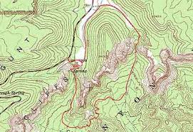
Here's an example. The parallel lines that curve and flow are lines of elevation - they show mountains and valleys. The green colour of the map indicates a forested area. There are blue lines on the map - those are rivers, creeks, and streams. There aren't any lakes on this example.
