How do you interpret topographic maps?
1 Answer

Topographic maps are interpreted by reading the contour lines.
Explanation:
Topographic maps are used to convey information about slope, elevation, and distance. They are a way of displaying features such as mountains and valleys on a one-dimensional piece of paper.
Topographic maps contain contour lines, which connect areas on the map that are of equal elevation. Index lines are darker and they are sometimes the only lines labeled with a number. In the image below, the index lines are a darker shade of brown.
Contour lines:
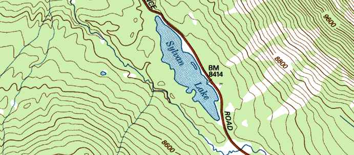
The spacing of lines also conveys information. The closer the contour lines are to one another, the steeper the slope. The further apart the lines, the less steep or flatter the land is.
The difference between two lines is the contour interval. This is the elevation between two contour lines. In the image above, we could determine the contour interval by doing 9600-8800=800, counting the number of lines between 8800 and 9600, and then dividing 800 by the number of lines between the two.
If a contour line crosses a river or a stream valley, it will make a V-shape with the point of the V pointing uphill.
Check out this webpage for a more comprehensive guide to topographic maps including a symbol key.
