What would the topography of an area be like if the contour lines were close together, and if they were far apart?
1 Answer

If contour lines are close together, it is a very steep slope; if they are far apart, it is a gradual slope.
Explanation:
The distance between contour lines represents a change in elevation. Many maps are in either a 1:24 000 scale (in the US) or a 1: 25 000 scale (metric); on these maps, the contour interval is 10 feet. (This can be found along the edge of the map.)
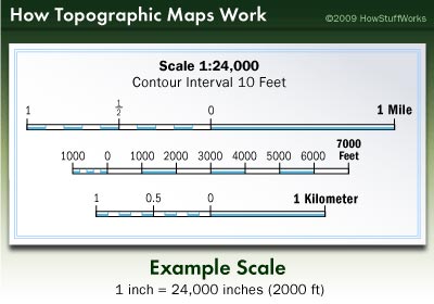 Picture from How Stuff Works: Topographic Map Scale
So each of the brown contour lines on this particular map show a change of elevation of 10 feet. If the lines are close together, it means that the elevation change of 10 feet happens over relatively little linear distance. The closer they are together, the steeper the slope.
If the lines are far apart, it means that the elevation change of 10 feet happens over a longer linear distance. This is a gentle slope, and would be easier and safer to walk.
This diagram shows how the contour lines relate to the topography that it represents:
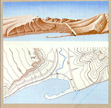 Picture from Brooklyn College's Geology: The Science of our World
On the left side of the map, there is a steep cliff shown by the many lines close together. The central river valley is much flatter; that's why the distance between the lines is much greater.
