Why do clouds usually form at the leading edge a cold air mass?
2 Answers

That is where it begins to condense the moisture in the warmer air mass into which it is moving.
Explanation:
The capacity for moisture in cold air is less than that of warm air. Thus, any "clear" cold air already has less than its maximum amount of free moisture, and will not form clouds.
Warm air can contain much more moisture, and even "non-saturated" warm air may contain much more moisture than can be carried in cold air.
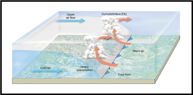
When a colder air 'front' (the boundary between a cold air volume and a warmer air volume) encounters warmer air with more moisture than it can hold, it begins the first stages of precipitation by condensing the excess moisture into tiny droplets that form the clouds. Continued mixing, and sufficient water content in the warmer air will eventually lead to nucleation of the tiny water particles into raindrops - liquid water heavy enough to fall from the cloud to the earth.
Cold air pushes warm air aloft.
Explanation:
As cold air is more dense than warm air, the leading edge of a cold air mass works like a plow, pushing warm air upward.
https://aesnotes.wordpress.com/2013/07/08/fronts/
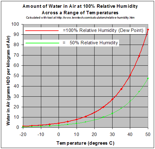
As with any rising air the temperature will drop due to a drop in pressure as per Gay-Lussac's law. As the temperature drops the relative humidity increases since the amount of water vapor the air can hold is based on the temperature of the air.
https://goldsealnews.wordpress.com/2012/03/20/measuring-humidity-in-your-home/
So if the rising air is 20 degrees and at 50% relative humidity, the number of grams per kilogram of air (absolute humidity) will remain the same but when the air cools to 10 degrees it will then be about 100% relative humidity. At 100 % relative humidity the water vapor will begin to condense forming clouds.
