Question #eb380
1 Answer
It starts as the boundary between 2 air masses.
Explanation:
An air mass is a large section of the troposphere that takes on the characteristics of it's source region. They are either continental (forming over land) or maritime (forming over water). They are also classified by the heat regime of their source region (arctic, polar and tropical). So you get a continental arctic air mass forming over a cold dry area.
The transition area between 2 air masses is known as a front. This term was used to describe the area as it appears similar to a front on a battle field map.
Whenever a front forms there is a colder and a warmer air mass. Since there are always air masses there are always fronts, however they are not displayed on a weather map until the air starts moving.
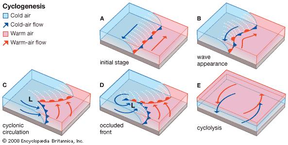
https://www.britannica.com/science/cyclogenesis
Since there is a temperature different between the air masses, there also has to be a pressure difference. This pressure gradient causes the air to start to move. Since the Earth is rotating, the air is deflected as it moves, but the point is a wind starts. (A on the picture above).
Then there becomes a localized low pressure on the front. There are a lot of things that can cause this, like humidity, localized heating differential or topography. Whatever the reason, the front forms a "kink" in it (B).
Once there is a kink, the wind causes the cold air mass to invade the warmer air mass. This motion also causes the cold air to retreat on the other side of the low. The trailing edge of the retreating cold air is known as the warm front (C).
